Batman's kitchen CTF 2026: Eye on the Sky & Eye on the Sky 2 Writeup
Goal: Determine the aircraft’s marketed flight number (operating airline) and the baggage carousel number.
Overview
In this OSINT challenge for Batman’s kitchen CTF, we were given a single photo (sky.jpg) containing a mountain and a small aircraft silhouette above it. And 2 tasks were given with this:
-
get the flight number and baggage carousel number of the plane in the photo
-
determine the location where the photo was taken
To solve this challenge, the main issues we had to solve were to identify the location of the mountain and, a time window when the photo was taken and some brief understanding of the direction where the photo was taken. With this information, and some geometry tricks (thanks to the available metadata of the photo) we were able (using an ADS-B replay) to reduce the number of candidates to 4, and then check the baggage carousel number for each of them until we found the correct one. With the correct flight identified, we had some extra information to use in our advantage to find the location of the photographer, as we knew the exact position and altitude of the plane at the moment the photo was taken and the position and altitude of the mountain, so we could make an estimation of the distance between the photographer and the plane, and then use that distance to find the location of the photographer along the line defined by the mountain and the plane.
Challenge statements
Part 1 — osint/Eye on the Sky
Goal: Determine the aircraft’s marketed flight number (operating airline) and the baggage carousel number.
Flag format: bkctf{<flight_number>-<carousel>} (no spaces)
Part 2 — osint/Eye on the Sky 2
Goal: Determine the location of the photographer.
Flag format: bkctf{<location>} (lowercase, remove spaces)
Inputs
sky.jpg: A portrait-oriented photo containing a distant mountain and a small aircraft silhouette above it.image.jpg: The same image under a different filename.
Methods and results
1. EXIF/metadata extraction
The first step was to check for useful metadata using exiftool, which can reveal parameters such as timestamps, GPS location (if present), and optical/shooting information.
Command used:
exiftool sky.jpgFull output (as recorded):
ExifTool Version Number         : 12.40
File Name                       : sky.jpg
Directory                       : .
File Size                       : 4.1 MiB
File Modification Date/Time     : 2026:02:22 01:12:45-05:00
File Access Date/Time           : 2026:02:22 01:13:21-05:00
File Inode Change Date/Time     : 2026:02:22 01:13:21-05:00
File Permissions                : -rw-r--r--
File Type                       : JPEG
File Type Extension             : jpg
MIME Type                       : image/jpeg
...
Date/Time Original              : 2026:01:19 09:18:43
Create Date                     : 2026:01:19 09:18:43
...
Create Date                     : 2026:01:19 09:18:43.44
Date/Time Original              : 2026:01:19 09:18:43.44
Modify Date                     : 2026:01:19 09:18:43.44
Thumbnail Image                 : (Binary data 4701 bytes, use -b option to extract)
Lens                            : 75.0 - 300.0 mm (35 mm equivalent: 116.6 - 466.3 mm)
Circle Of Confusion             : 0.019 mm
Field Of View                   : 15.5 deg
Focal Length                    : 85.0 mm (35 mm equivalent: 132.1 mm)
Hyperfocal Distance             : 11.68 m
Light Value                     : 16.0
1.3 Extracted constraints
From the EXIF dump, the constraints used downstream were:
- Timestamp:
2026-01-19 09:18:43.44with TZ = -08:00 (Los Angeles). - Focal length: 85 mm (APS-C crop factor 1.6 given).
- Field of view: 15.5° (critical for pixel→angle conversion).
The timestamp was converted to UTC for ADS-B replay:
2. Landmark identification (mountain)
A reverse image search (e.g., Google Lens) was used to identify the mountain profile.
The peak was identified as Mount Rainier (Washington State, USA). This also constrained the likely viewing sector to a north/northwestern viewpoint based on the visible face profile.
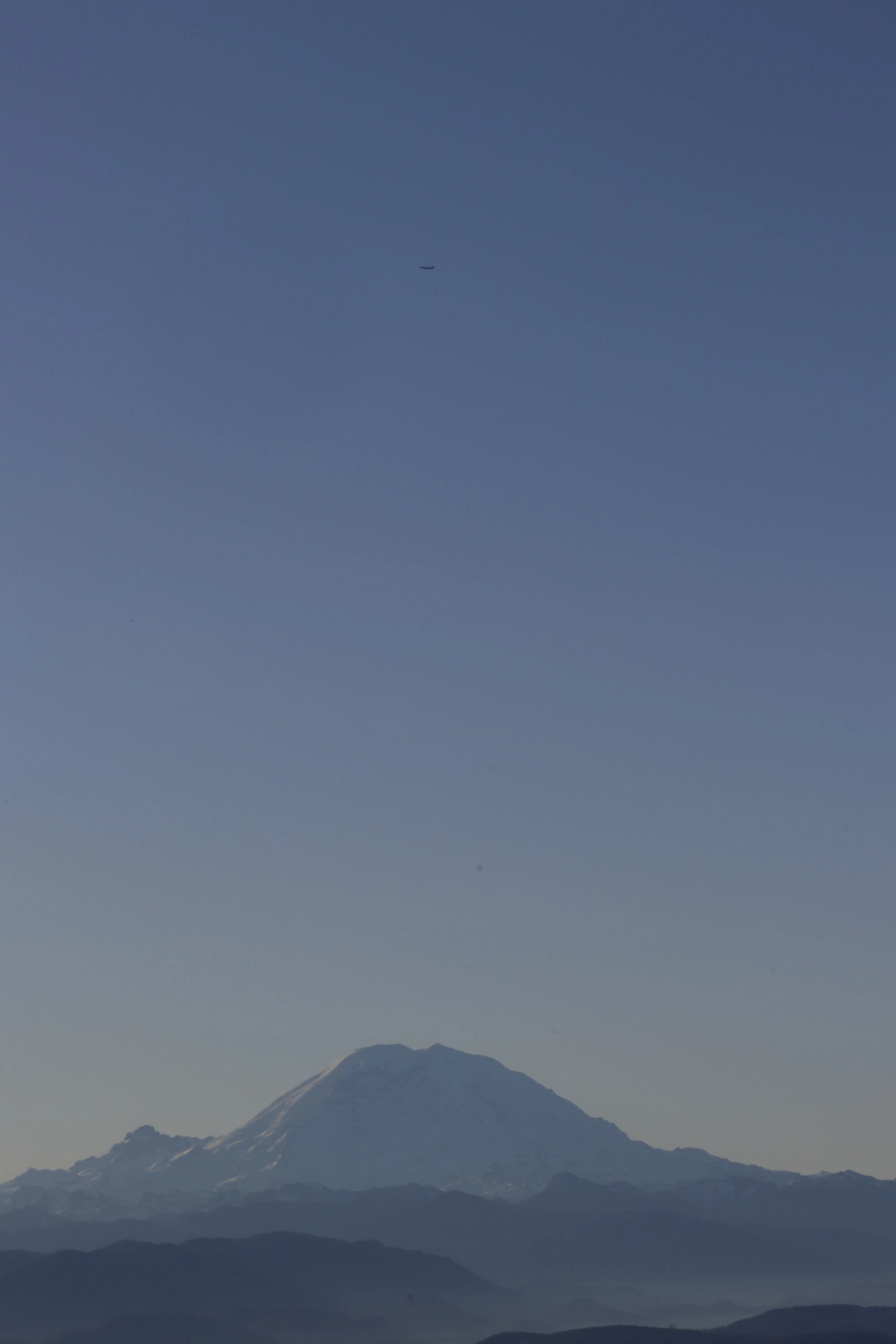
Figure 1:
sky.jpg(corrected for EXIF rotation).
3. ADS-B replay at capture time
Historical ADS-B traffic was queried using ADSBexchange:
The replay time window was centered on , matching the EXIF time within sub-second tolerance.
The ADS-B view at the replay time showed multiple aircraft in the region. A preliminary set of plausible candidates (based on proximity and altitude bands) included:
SKW3740(SkyWest)ASA4(Alaska)ASA265(Alaska)QXE2117(Horizon)
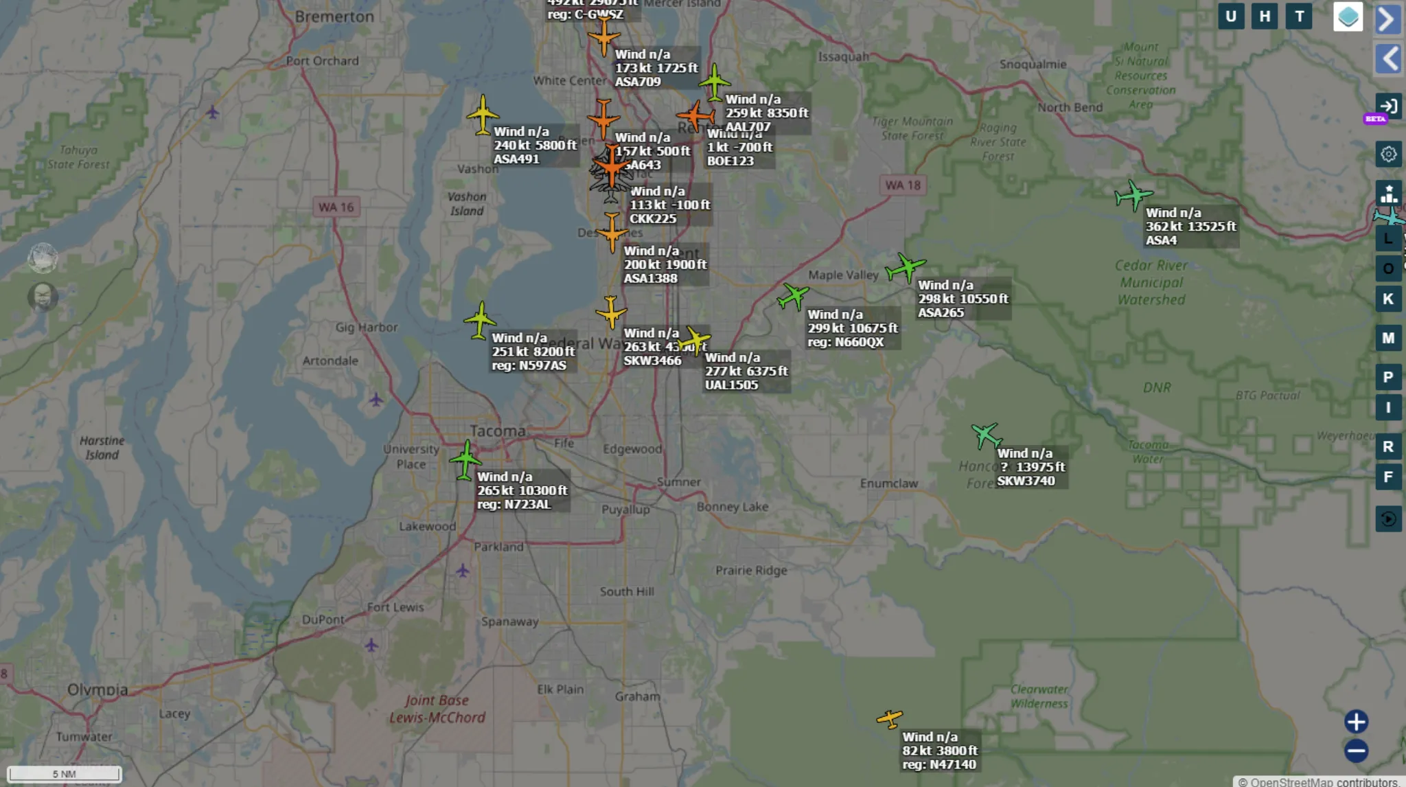
Figure 2: ADS-B replay overview around the Rainier region at .
4. Angular constraint derivation from image geometry
Because the aircraft is only a few pixels in size, direct identification from livery is infeasible. Instead, the solution leverages geometric constraints: with a known camera field of view, a pixel displacement corresponds to an angular displacement in elevation.
4.1 Pixel → angle conversion
Given:
- EXIF field of view (vertical, portrait):
- Rotated working image height: px
- Measured aircraft vertical offset above the mountain summit silhouette along the same image column: px
Approximate angular separation:
4.2 Elevation angle estimate
From a north/northwestern viewpoint at ~70–80 km range (consistent with typical traffic corridors in the Tacoma/Seattle area), the summit appears approximately – above the horizon (observer-elevation dependent). Therefore, the aircraft elevation was estimated at:
4.3 Apparent angular width sanity check
In the rotated image (width px), the aircraft blob spanned px. Using a short-side horizontal FOV of (85 mm on APS-C in portrait), the apparent angular width was:
This is consistent with a commercial jet at tens of kilometers range (e.g., Embraer-class or 737-class) and implies an altitude band on the order of – ft given the elevation estimate, disfavoring low-altitude aircraft candidates.
5. Aircraft identification and baggage carousel resolution
5.1 Candidate testing
Using the filtered candidate set from ADS-B replay, each candidate was checked on FlightAware to retrieve the baggage claim carousel associated with the flight.
The flag format required:
- Flight number as marketed by the operating airline (no spaces)
-- Baggage carousel identifier
5.2 Result
After testing the four candidate flight + carousel combinations, the accepted flag was:
bkctf{AS265-23T2}
This identifies the aircraft as Alaska Airlines marketed flight AS265 with baggage carousel 23T2.
6. Photographer location inference (Part 2)
With the aircraft identified, its precise state vector (lat/lon/alt) at capture time is available from ADS-B history. Because the aircraft appears vertically aligned above Mount Rainier in the image, the camera’s bearing is approximately collinear with the mountain–aircraft line, making perspective correction negligible.
6.1 Known values (from ADS-B + terrain)
- Mount Rainier: , elevation ft
- Aircraft (AS265) at capture time: , altitude ft
- Distance aircraft→mountain: km
6.2 Line-of-sight vector
Vector from mountain to airplane:
Since the aircraft lies N–NW of the mountain, the photographer is located further N–NW along the same line (looking S–SE).
6.3 Distance to aircraft via apparent elevation ratio
Even though the plane is physically lower than the mountain, it appears much higher above the horizon in the photograph, implying the aircraft is much closer to the camera than the mountain.
Deriving the Apparent Height Ratio (): To calculate exactly how much “higher” the plane appears in perspective, we analyzed the vertical pixel distances along the image’s Y-axis. First, we estimated the true eye-level horizon line near the base of the visible terrain. We then measured two vertical pixel segments from this horizon line:
- The distance to the mountain summit ().
- The distance to the aircraft ().
The apparent height ratio () is defined as the quotient of these two apparent elevations:
Based on visual pixel estimation from the cropped image, the aircraft sits approximately 4.5 to 5 times higher above the true horizon than the peak of Mount Rainier, yielding –.
Using the geometric relationship:
For :
For , increases to roughly km.
6.4 Back-projection to coordinates
Define the scale . With km and km:
Extend the mountain→aircraft vector by starting at the aircraft coordinate:
This corridor intersects the Tiger Mountain / Poo Poo Point / Squak Mountain region. Testing prominent viewpoints along this line yielded the correct location.
6.5 Result
Accepted flag:
bkctf{poopoopoint}
Final flags
- Eye on the Sky:
bkctf{AS265-23T2} - Eye on the Sky 2:
bkctf{poopoopoint}